|
|
US ARMY CORPS OF ENGINEERS - WILMINGTON DISTRICT |
|
|
US ARMY CORPS OF ENGINEERS - WILMINGTON DISTRICT |
|
NEW!!! To View Recent Stages, Flows and Elevations Choose a River Basin on the Graphic Below -OR- |
||
| SAW River Basins: | ||
| Roanoke |
|
|
|
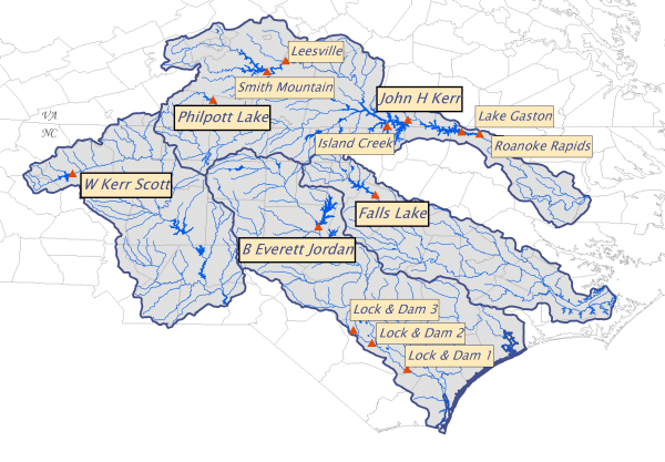
John H. Kerr Philpott Lake Smith Mountain Leesville Lake Gaston Roanoke Rapids |
||
| Neuse | ||
| Falls Lake | ||
| Cape Fear | ||
|
B. Everett Jordan L&D 1 L&D 2 L&D 3 |
||
| Yadkin | ||
| W. Kerr Scott | ||
|
Lake Levels and Guide Curve Target Levels for the past 180 days |
||
|
This page provides access to PROVISIONAL stream and reservoir project information from data collection platforms (DCP's) within the Wilmington District. DCP's are electronic devices installed at certain stream gage locations and dam sites. The DCP's gather information at predetermined intervals such as each 15 minutes, each 30 minutes or each hour. This data is then transmitted to a GOES satellite. The GOES satellite in turn rebroadcasts the information to receive stations on the ground where it is captured and managed. Computers in Wilmington retrieve this data periodically. Data is available in two formats: a collective format with information from all DCP's and a river specific format. Information in the collective format is PROVISIONAL and may not be up to date during weekends, holidays or when maintenance is being performed on the system. However, stream gage and some reservoir information in the river specific format will most likely be updated every one to two hours during the daytime. |
||